Copyright 1997 - 2021 by James B. Van Bokkelen . This document may be duplicated and distributed for non-commercial purposes only, all other rights reserved. Corrections and criticisms to me.
More general B&M information and a bibliography can be found on my Unofficial Boston & Maine RR Page .
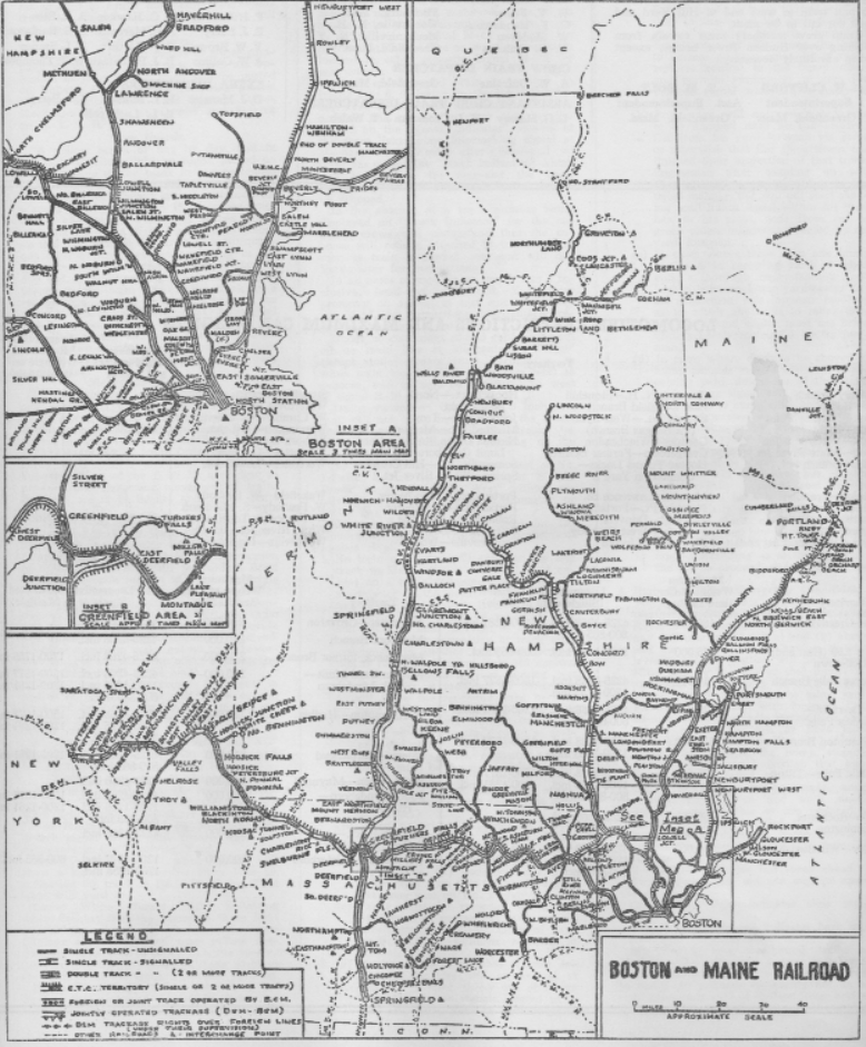
The B&M prior to 1970 could be divided up into eight basic modeling themes. Links to track charts of segments of each line below are from B&M Employee's Timetable #21, updated to April 1977. ETTs from the 1960s included a system map: This system map is from Employee's Timetable #4, January 4, 1964.
The former BC&M to Plymouth NH and the White Mountain Branch to Lincoln had been purchased by the State of NH in 1976
The Troy Branch had been the destination of Fitchburg Div. passenger trains until service ended in 1958, but was abandoned in 1972.
Until the Kittery - North Berwick segment was abandoned in 1952, the Eastern and Western routes each frequently saw passenger trains detoured from the other. I expect that's why the 'P' (Portsmouth) and 'D' (Dover) prefixes were applied to Automatic Signal numbers; prefix letters don't appear to have been used on other B&M Divisions.
What I've done covers the Eastern Route to Portsmouth pretty well, and the Western Route up to the Berwicks. I know the NH division to Lowell well enough, but I've only ridden the Fitchburg on fan trips long ago, and most of the Conn River only at night on Amtrak.
If anyone else has been making notes on lines I don't cover, I'd be happy to add them, with credit, so we all can find information when we need it.
Originally built as the Eastern RR between 1836 and 1840, this line followed the coast in Massachusetts and New Hampshire. Its eastern connection was the Portland, Saco & Portsmouth, completed in 1842. This was routed well inland due to early Maine laws protecting coastwise shiping. As part of their decades-long railroad war, the Eastern acquired the PS&P in 1872; the B&M responded by building its own route closer to the coast. The PS&P remained single-track; most of the North Berwick - Portland segment was abandoned in 1945, after CTC was installed on the double-track B&M line to the east. The portion from Portsmouth to North Berwick was abandoned in October 1952, but in prior years it carried between 25% and 30% of the Boston-Portland passenger schedules.
Because of tight clearances in the old Salem Tunnel, the line hadn't carried much through freight since the late 1920s, when locomotives and boxcars started to get larger. The tunnel was enlarged in 1957, as part of the project that eliminated the downtown grade crossings and replaced the station, but too late.
Passenger service was cut back to Newburyport in January 1965. By April, the Merrimac River drawbridge East of the station was taken out of service. Thereafter local freights worked each end separately. Passenger service was cut back to Ipswich in 1976, and freight service beyond Salem ended when the Beverly drawbridge burned in 1983. The MBTA re-instituted service to Newburyport in October 1998, after a major re-building that included replacing most bridges between Ipswich and Newburyport.
Major theme elements are large industrial areas in Everett, Chelsea and Lynn, salt-marsh crossings (including the B&M's longest straightaway, about 8 miles through Rowley, MA) and drawbridges over harbors and river estuaries. Before WWII, three of the four on-line draws were pile trestles with swing or bascule draw spans. The Merrimack River in Newburyport still has an interesting deck truss. It was originally built in 1888 as pin-connected and then strengthened with plate trusses along the track centerlines in 1922 (Fig. 10-47 and brief discussion in Paul Mallery's bridge book). The Piscataqua pile trestle in Portsmouth collapsed under a passenger train in 1939, pulled down by cables rigged from the rail/highway bridge under construction alongside it. The 1940 lift bridge had a single track on its lower level, underneath three lanes of the US 1 bypass. The 1940 bridge was demolished in 2017; its replacement has a railroad track deck too; the single-deck lift span can be aligned with either the road or the RR level under it. The 2017 bridge only carries occasional traffic to the Navy Yard in Kittery.
Conventions are: East is towards Portland, Right is towards the Atlantic, Diverge is facing point going East.
Everett: Mystic River bridge (Draw 7): pile trestle with 3-track folding/swinging drawspan (Fig. 13-11 in Bridge & Trestle Handbook by Paul Mallery, good photo coverage on-line via the Library of Congress). The two spans on the RH side failed one by one after about 1970. It was single-track for perhaps 10 years before being replaced with a prestressed concrete high-level bridge about 1990. Boston & Albany "Grand Junction Branch" to East Boston parallel on RH side. 0.5 mi beyond, Monsanto Acid Manufacturing Plant (1950s) on both sides of ROW served by both B&M (L) and B&A (R). Raw sulfur in piles delivered by ship, tank cars of many different acids shipped by rail. Next on the right Everett MTA/MBTA shops, New England Bolt Co. then Charleston Chew Candy plant. Everett Junction (2-track Saugus Branch diverges left before Rt. 16 overpass), then under the bridge (Broadway-Rt. 1, MTA trackless trolleys). After the bridge on left was Everett depot, on the right was B&A Tower E-5, which controlled access to the Esso and EG&F plants. Behind the tower was the Esso oil refinery (B&A 25 loaded tank cars/day). Next, on the right was Eastern Gas & Fuel Associates (EG&F) Coke Works, Mystic Iron blast furnace, and Warren Pipe & Foundry. The Coke Works was served by its own in-plant railroad (~20-30 miles of track with 7 operating 0-6-0s and 0-8-0s) which connected to both the B&A (20-30 loaded coke cars/day) and B&M (15-25 loads/day). A short branch line off the B&M (L) served industries between the Revere Beach Parkway and the main. Kianize Paint (L) was on the corner of Second St. at the Everett/Chelsea border.
Chelsea: B&A line parallel on R, RoW 4-6 tracks wide. Post-war produce terminal on R, served mostly by NYC/PC/CR in the years I remember it, received 100+ reefers/day into the early 1980s. Many light industries on both sides of RoW, area on R devastated by fire in 1973?. 5-track public delivery area on LH W. of Rt. 1 overpass, Post-1988 Chelsea station between Rt. 1 and Broadway, B&A line diverged RH toward East Boston E of Broadway overpass. Small yard w/assigned switcher (Chelsea Goat) on both sides between B&A curve and Eastern Ave. grade crossing
Revere: Trestle over branch of Chelsea Creek E of large brick Forbes Lithograph complex on RH, former Eastern RR main to East Boston converges RH, serves many oil terminals along Creek. Long straight fill from Rt. 1A overpass across Saugus marshes, trestle with bascule drawspan over Saugus River.
Lynn: G.E. River Works (jet engines, turbines and generators, several GE-owned 44-ton plant switchers into the 1970s) on river bank, with a middle track and outside running tracks which served the main GE plants on the LH and the WWII-built marine Gear Works on the RH. River Works station at grade crossing was not in timetable prior to MBTA era but scheduled stops were indicated by a timetable note. Small yard on LH adjoining other Lynn industries between GE and the elevated RoW of the 2-track Saugus branch converging on LH. West Lynn station on LH and West Lynn Creamery on RH along elevated 4 track RoW, several elevated spurs into 2nd story of industrial buildings, 2 track spur to plastics plant on RH (tank-hoppers of pellets). New Lynn station W of Central Square, old Lynn Station was E beneath elevated platforms w/umbrella sheds. Engine terminal (60' turntable, no coaling facility in 1937) was on RH just E of the station, closed early 1950s. New Haven-style concrete signal tower opposite. From there 4 track RoW continues in cuts and fills through closed East Lynn station past Durkee-Mower plant on LH (tanks of corn syrup for Marshmallow Fluff) almost to Swampscott.
Swampscott: 6-storey pillastered factory on RH, coal trestle on LH West of station (station still extant, in good repair). Marblehead Br. diverged RH just E of station, large lumber yard on LH beyond curve. 3/4 mi. E, lead to Lynn Sand & Stone diverged LH. This generated 30+ cars/day of aggregate and fill traffic to Boston points into the early 1970s and had its own center-cab switcher.
Salem: Castle Hill was the name of the crossover at W end of yard lead (cut back 1990s). Salem Branch from Marblehead converged RH at throat of freight yard W of town. The pre-1955 station was a unique building with a granite castellated facade facing the single track tunnel and a wood/steel 2-track trainshed extending W. Old station demolished as part of new tunnel project; 1957 replacement station was in a cut at W end of new tunnel, supplanted about 1990 by a third station E of tunnel on site of former engine house. The original tunnel was stone lined, with grade crossings at each end. Engine house lead and line to Peabody diverged LH at E portal, brick Salem Tower inside wye (extant). Article with track and signal diagram in Summer 1981 B&M Bulletin. New concrete tunnel was still single track, but moved wye switch under a road overpass. Roundhouse (60' TT, 275 ton wood coal tower) closed before reconstruction ended. West leg of the Peabody wye sacrificed for new station in early 1990s. The Parker Bros. plant on RH opposite engine house/1990 station was demolished mid-1990s. Short branch to harborfront and power plant (Salem Willows) diverged RH just beyond Northey Point, which was where double track resumed.
Beverly: Pile trestle crossing Salem Harbor, steel swing span. Trestle burned 1984, replaced w/concrete trestle. E of river, switchback to in-street industrial track converging RH from across Cabot St. along North bank of river from Gulf Oil terminal (not shown in 1941 track diagram). After a long rock cut, Beverly station on LH, converted to restaurant early 1960s. East of station, double track Rockport Branch diverges RH, small yard on LH, with 75' turntable in steam era, where commuter trains change ends. Far end of yard lead extended into huge United Shoe Machinery complex on L.
North Beverly: Station stood into 1980s when it burned, team track on RH E of station. End of double track 1/2 mi. E after 1959, then short upgrade through golf course.
Hamilton/Wenham: 70' turntable on RH West of station removed w/Essex Branch. Essex Branch (abandoned 19-Dec-1942) diverged RH at station. Old station on LH just W of Rt. 1A grade crossing demolished 1960s, small freight station remained as taxi office into 1980s. Lumber yard on LH East of Rt. 1A had two spurs with a diamond where they crossed.
Ipswich: 80 car CTC siding E of Ipswich River bridge (26.72) after 1959, former location of EB and WB sidings along double track. Post-1956 section house East of E siding switch. The original station on RH facing sharp LH curve was demolished in late 50s, replaced with liquor store, cafe and steel panel tower for gateman. All these buildings were replaced in the 1980s by the bank now on site. New platform built W of grade crossing mid-1980s. Several coal and lumber spurs: two on L along siding, one on each side E of old station. Concrete and girder Rt. 1A overpass (28.53) replaced 2012.
Rowley: through/deck girder bridge over Rowley River (30.94), B&M era station W of grade crossing 600 yd. E of bridge. Station burned and replaced 1930, replacement burned 1969, plans in January 1974 Model Railroader and NER Coupler no. 2-89. Team track E. of station on LH with freight house (demolished circa 1959, site of post-1989 high-level platform and parking lot), section house opposite. Rt. 1A overpass (31.91) E of station in two segments - older concrete arch to E, later columns supporting span girders to W. Construction article with photos in April 2014 Railroad Model Craftsman.
Newbury: Two through girder spans over Parker River (33.25). Granite slab culvert between Kent's Island and Hay St. Pre-WWII depot on LH just E of Hay St, spur opposite. Granite slab culvert over Little River at Four Rock (Boston St. crossing, no bridge number on track chart) replaced in MBTA reconstruction.
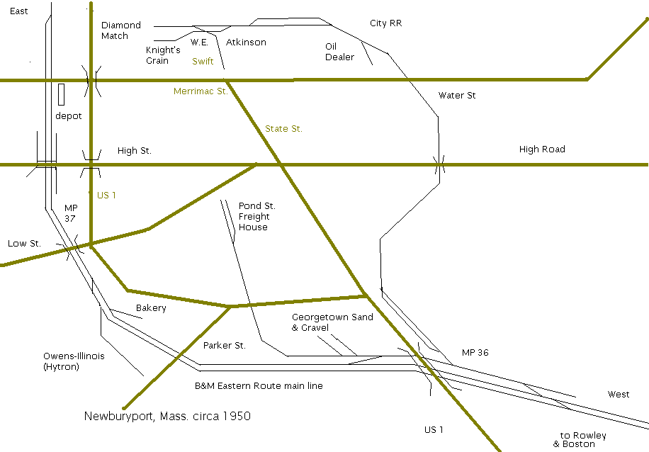
Newburyport: Newburyport West at the Hanover St. crossing in Newbury was resumption of double track 1959 - 1965. Abutment of Georgetown, Rowley & Ipswich trolley overpass on R 100 yd. E (built 1900, abandoned 1919, approach fill removed 1999). City RR (2 mi. branch serving riverfront industries, no customers by 1969) diverged R. Originally built by Newburyport RR from Wakefield, diamond crossings removed before 1900. Used occasionally for holding cars until late 1970s, now site of new passenger train layover yard. US Route 1 overpass (36.06) initially built 1935, concrete deteriorated by 1970s, taken out of service about 1985, replaced 1996. East of US 1 overpass, Georgetown Sand & Gravel (incoming cement) plant on R, now main parking lot of new station. Newburyport Branch (built as Newburyport RR about 1850) from Georgetown converged from L, crossed at diamond (until 1900) 3/4 mi. to Pond St. station. Post WWI, spur to freight house (old Newburyport RR station) diverged R, removed 1955. Team track with loading platform on stub of spur used into 1970s.
East of Parker St. crossing, Hytron warehouse on L (post-1955 Owens-Illinois: inbound tank-hoppers of plastic pellets, outbound boxcars of blow-molded bottles), Prost Bakery R (postwar, inbound covered hoppers of flour, converted to machine shop circa 1965), Route 1 parallel on R. 5-track Low St underpass (36.90, only 2 spans used post WWII, removed circa 1985). Brick roundhouse (60' turntable, standpipe w/o tank) on RH, 1916 concrete signal tower on LH (both closed 1941-2) West of High St. underpass (37.14). Original High St. overpass was cut & cover "Arch". Gauntlet track and ball signal added for double track circa 1880. Replaced with current 3 track underpass 1912-1916. Washington St. grade crossing gates made automatic about 1951 (streetcar crossing 1888 - 1897). 1887 brick/stone station on RH (Winter St. side) E of Washington St (burned 1969). Fill beyond station over Merrimack St. (37.37) to end of double track 1937 - 1965 at Merrimack River bridge (37.50) : 7 span double track deck truss, deck truss swing span, WB (upstream) track removed 1937, bridge out of service Spring 1965.
Salisbury (MP 39.32): Stone arch (37.83) carries Friedenfels Road under bridge approach, fills across marsh (now bike path) with single through girder span over marsh creek (now pipe culvert) to Mudnock Rd. overpass (39.07, filled circa 1984). Station on LH, short runaround opposite just west of MA 110 overpass (39.34, filled circa 1984). Amesbury branch diverged LH east of overpass. No freight customers post-WWII. Single span through girder overpass (39.99) over US 1 East of junction removed 2002.
Seabrook (MP 42.66): Station at MP 41.47 (by Collins St. Rt. 286) timetabled as Atlantic, but only a few trains made flag stops by 1958. 40 car siding at Seabrook post-1937. Little freight activity except inbound construction materials during nuclear reactor construction R at Rocks Rd. (small yard, wye into plant 1974 - 1984).
Hampton Falls (MP 44.38): Freight station on LH at edge of Hampton River marsh crossing, no longer a passenger stop by the 1950s.
Hampton (MP 46.52) : Plastics plant on LH W of depot. Former Hampton station now motorcycle dealership on RH W of NH 27 overpass. Plastics plant and lumber yard in Hampton were the last industries served from Portsmouth. 2-mile siding Hampton to North Hampton post-1937 began E of NH 27 overpass. Rail removed Hampton - Portsmouth 2013.
North Hampton (MP 48.69): 2 mile siding from Hampton ended W of No. Hampton depot on RH, W of NH 111 overpass. Depot survives as residence in 2020. HO scale kit of North Hampton station was offered by Sheepscott, now by B.E.S.T.
Breakfast Hill (MP 51.40): Originally Greenland, renamed 1930s to avoid confusion with the Concord & Portsmouth station on the other side of town.
Emery (MP 55.98): Line from Manchester & Rockingham Jct. converges LH. Small operator shelter RH. Current junction location dates to construction of US 1 Portsmouth Bypass in 1939, to avoid construction of a second bridge. Original route from Greenland didn't converge till just west of the Portsmouth yard. Double track Emery to Portsmouth removed circa 1960.
Portsmouth (MP 56.91): Line from Manchester & Rockingham Yard and roundhouse with 70' turntable on LH West of station. Turntable and roundhouse survived, partly collapsed in 2020. Station (R) survived into 1990s, heavily modified, as a business. Sharp LH curve E of station, pass marine industries, main line curves RH onto lift bridge, former branch to Dover continues straight along fill across cove. 1939 2-level lift bridge replaced 2016-18. New bridge has only 1 lift deck, lowered to rail level for infrequent moves to Portsmouth Navy Yard. Dover line was severed at Dover Point draw in 1930s, presently active into Newington serving industries. 1952 to 1980s spur to Pease AFB crossed the Spalding Turnpike at grade. Two 50,000 gal. water tanks listed at Portsmouth in 1937.
Kittery Jct. (MP 57.7): Compact station on LH, downstream and below US 1 approaches to lift bridge, demolished after abandonment of line to No. Berwick in 1952. Navy Yard branch diverges RH along water, main line ducked LH under highway, overpasses removed 2017, RoW now ME Route 236 through Eliot to Great Works.
Eliot (MP 63.23): Double track to Jewett began at Spinney's Switch (about MP 60.7), removed 1930s. Depot was at Depot Rd. crossing. Right of way through rock cut still visible E of ME 236 between Worster Rd. and Goodwin Rd. (ME 101).
Jewett (MP 67.45): Conway Branch to Great Works and Somersworth diverged LH till 1940s. Water tank & standpipe W of grade crossing. Depot LH between branch and main. Double track ended. Great Works River bridge removed after abandonment
Agamenticus (MP 69.94): Depot LH, short siding E of Emery's Bridge Rd. grade crossing. East of Knight's Pond Rd. crossing, fill across Knight's Pond intact.
North Berwick (MP 74.53): RoW became Eastern Ave. after 1952 abandonment. Sidings both sides, depot LH (still standing 2020) between Eastern and Western Route main lines. Until about 1930 tower and diamond crossing with Western Route (B&M line to Portland via Wells, Old Orchard built after Portland, Saco & Portsmouth RR bought by Eastern RR 1872). Replaced with crossovers and CTC for more routing flexibility until former PS&P abandoned 1945.
Beyond North Berwick to the outskirts of Biddeford the land was rocky, swampy and thinly inhabited. Nevertheless, the Portland, Saco & Portsmouth laid out a 10-mile straightaway from North Berwick to West Kennebunk. A segment from Biddeford into Saco is still in use, terminating at an industrial park. Between Saco and Portland Terminal Tower 1 (west end of Rigby Yard, S. Portland) there were several long marsh crossings, still evident. Much of this route can now be walked/bicycled as the Eastern Trail (bike bridge over I-95 visible E of Kennebunk Rest Area).
Double track to Gloucester (MP 31.59), cut back about 1960 to Wilson (MP 31.25) with a spring switch interlocking at the Annisquam River draw due to drainage problems in the cut W. of Gloucester. Drawings of the Pride's Crossing (MP 22.17) depot were in the October 1958 Model Railroader. Bascule drawspans at Manchester and over the Annisquam River between West Gloucester and Gloucester. The November 1980 Model Railroader contains plans and a construction article for the Annisquam River Strauss Heel-Trunnion span, see also Fig. 13-30 in Mallery's bridge book. The LePage glue factory (now condos) is on the RH in West Gloucester, but by 1970, the only significant industry was Gorton Fish E of Gloucester station on RH side at sharp LH curve. Until Nov. 1961, well after locomotive-hauled trains were gone, there was a John Armstrong-style "reverted loop" on the RH side W of Rockport. Its switchpoints faced the stub station. Engines would cut off their trains, back around the loop, and couple up again for the return to Boston. Rockport was also the site of a pillar crane at the team track, and the last semaphore signal on the B&M - survived into the 1970s.
Two branches entered Marblehead - one from Swampscott that carried commuters to Boston, but little freight, and one from Salem that served industries and carried mostly deadhead passenger moves between Marblehead and the coach yard and roundhouse at Salem. The line from Swampscott was abandoned when passenger service ended in 1959. See both R.W. Jones and Plant & Plant for extensive photos of the last days of steam on this line. The Salem branch was pruned back in several stages. The Salem end was torn up after Osram/Sylvania stopped using rail in the 1980s.
Until the end of passenger service circa 1960, there was double track from the wye at Northey Point to just short of Peabody Sq. There the South Reading branch (which originally went through to Wakefield) diverges left for a mile or two to the Eastman Gelatine plant. The former South Middleton branch (originally Salem & Lowell) went straight. The Danvers branch diverged R. towards Danvers, where it joined the Topsfield Branch (former Newburyport RR from Wakefield Jct.). Until the new Salem Tunnel was finished in 1957, the Newburyport RR and Salem & Lowell were how the High Car Job moved oversized cars to and from the North Shore. Article/map on operation circa 1981 in Vol. 11 #2 (Spring 1982) Bulletin.
The Essex branch was single track, with a small turntable and a few sidings at the terminus. Essex had some importance as a fishing port and shipbuilding center when the line was originally built, but in the end neither the freight nor passenger traffic justified retention even in the depths of WWII gas rationing. Always a haunt of 4-4-0s and other small power, usually operated as a shuttle connecting with mainline trains at Hamilton/Wenham.
3.8 mi. branch, passenger service ended mar. 1936, said to have been abandoned 1972 but listed in my 1977 ETT. Amesbury was a busy mill-town, built and shipped carriages & wagons, then later trolley cars and complete auto bodies via rail. Automotive industries were major shippers into 1950s, then moved/declined. Little passenger service after WWI era, due to trolley/bus competition. Small engine terminal (60' turntable) remained open after Newburyport closed, last steam 7/1/50. I believe that into the mid 1950s operations included the assigned 44-ton switcher running down to Newburyport to work industries there and exchange cars with main-line locals. Map, history and steam-era photos in Vol. 10 #3/#4 (Spring & Summer 1981) Bulletin. Salisbury Point station preserved off-site, HO scale kit available. Amesbury station still extant as restaurant.
Pre-1952: Some through passenger trains to Bangor, semi-expresses to Portland, commuter service to Portsmouth, Rockport, Danvers/Topsfield, Marblehead (often via Saugus Branch to Lynn). Short turn points for commuter trains were Lynn (mostly Saugus Branch trains) Salem, Beverly, Hamilton-Wenham and Newburyport. In the final years of passenger service on the Amesbury branch, it was operated as a shuttle from Newburyport.
Post-WWII freight service was provided by a main-line local Boston - Portsmouth and haulers (one known as the "Camel") Boston to Salem, adding and dropping at Lynn and possibly Chelsea. In the mid-50s, another main line local ran Boston - Amesbury. Portsmouth Local was daily through the 1950s, then eastbound Mo/We/Fri, westbound Tu/Thu/Sat till the Merrimack River bridge went out of service Jan. 1965. Salem switchers operated as far as the Gulf Terminal and to Peabody. Locals from Salem ran to Rockport and Danvers/Topsfield. Until the Salem Tunnel rebuilding was complete in 1957, the "High Car" local operated Boston - Wakefield Jct. - Peabody - Northey Point for PRR X31 round-roof boxcars and other post-1930 house cars.
As of 1937, all B&M steam locomotives classes could work between Boston and Lynn. H-3 0-8-0s and T-1 2-8-4s were allowed between Lynn and Salem yard. The largest engines that could work through the Salem tunnel and beyond to North Berwick were K-8 2-8-0s and P-3 4-6-2s, though Maine Central 2-8-2s and 4-6-4s are allowed in some ETTs. The tunnel clearances were close, and the pile trestles at Beverly and Portsmouth probably restricted engine weights as well; the latter would have disappeared after the lift bridge was completed in 1940, but because the Squamscott River bridge in Greenland, NH on the line from Rockingham Junction was also frail, the restrictions were never worth updating.
In 1952, through passenger service to Portland ended and the track from Kittery to North Berwick was torn up. The Salem roundhouse was one of the last to serve steam, which persisted on commuter runs until July 1956. In 1957, the new tunnel ended the need for a special "High Car" local, but many industries remained active in Peabody and Danvers, and the complex of branches between Salem and Wakefield Jct. was served from both ends. Passenger service ended on the Saugus Branch in May 1958, the Marblehead Branch in June 1959 and the Danvers Branch also in 1959. Passenger trains to Portsmouth were all RDC by Fall 1956.
Passenger service beyond Newburyport to Portsmouth ended in January 1965 and the Merrimack River drawspan was taken out of service. Thereafter, a local worked West from Portsmouth to Hampton and Amesbury, while symbol B-21 worked as a hauler Boston - Salem, and then ran to Newburyport Wed/Sat, Rockport Tue/Fri and Danvers/Topsfield Mon/Thu. After the East Somerville yard finally shut down except for local destinations about 1980, train SAED/EDSA brought cars to and from East Deerfield via Lowell and Mystic Jct.
This is the part of the B&M I'm personally most familiar with, and I hope to be able to come up with a good plan. I am modeling Newburyport, with the City RR branch, but after the Georgetown line and the towers, roundhouse and yard were removed. My space pushed me in the direction of modeling the Newburyport draw, and I have a stand-in for Salem that makes the Towerman's job a hot spot, with engine terminal and coach yard East of the single-track tunnel, and the freight yard and passenger station to the West.
Industrial modelers can consider Eastern Gas & Fuel's complex: It included a tide coal handling, a large gas plant, coke handling, a blast furnace and a foundry, using steam switchers and interchanging with two common carriers. GE's River Works in Lynn also had a private plant railway which used a lot of girder rail and was electrified before WWI using home-built 'critter-style' locomotives. GE-44 ton diesels replaced them late in WWII.
Until the 1920s, much of the granite quarrying industry in Gloucester and Rockport was rail-served. Lynn Sand & Stone owned a diesel switcher into the 1970s.
The branchline modeler has possibilities in the Essex Branch (very relaxed, mostly passenger service in later days) and the Amesbury Branch (mostly freight after the streetcars took all the passengers before WWI, but interesting freight - carriages and streetcars, later automobile bodies). The mesh of lines between Salem, Peabody and Wakefield, Lowell, Lawrence and Haverhill offer a wide variety of rural New England settings and traffic densities.
Immediately after WWII, both the Western and New Hampshire Routes were high-capacity, high-speed track with heavy passenger and freight service. 70 MPH was allowed except for sharp curves and through busy terminals. The Western Division was double track from Sullivan Sq. in Charlestown to Portland Terminal Tower 1 at the west end of Rigby Yard in So. Portland. The New Hampshire Division was double track to Concord NH, where the passenger service divided to reach Plymouth and Woodsville on the former Boston, Concord & Montreal, and White River Jct. via the former Northern RR. From about 1930, most freight used the easier grades to WRJ.
The original Boston & Maine RR was built between 1833 and 1843 from a connection with the Boston & Lowell in Wilmington, MA to North Berwick, Maine via Haverhill and Dover. The B&M opened its own route from Wilmington Jct. through Reading and Malden to Boston in 1845. The connecting Portland, Saco & Portsmouth handled B& and Eastern RR trains through to Portland, MA.
After the Eastern acquired the PS&P in 1872, the B&M built its own line to Portland through Wells, Kennebunk and Old Orchard. The new line was built close to populaton centers, where the old PS&P had been required to stay more than 100 feet above sea level by the shipping lobby. The PS&P track remained in service after the B&M took over the Eastern in 1883 as a single track bypass route for freight and through passenger (it missed most of the timetable passenger stations) until 1945, when the B&M route was completely double tracked with bi-directional CTC from Dover to P.T. Tower 1.
The New Hampshire Division main was originally built by the Boston & Lowell, Nashua & Lowell, and Concord RRs. I'm treating the two divisions together because 1) the mill towns they served were quite similar in industry and architecture, and 2) both lines were more or less water level and double-tracked, with lots of B&M branches, but no other RR presence (except the New Haven at Lowell).
Medford Jct. (MP 3.38): Mystic River bridge: pile trestle with 4-track folding/swinging drawspan (Draw 8), replaced with concrete high-level bridge when MBTA Orange Line was extended parallel to B&M in 1976. Industrial area E of bridge, stub of branch to Medford Sq. diverges L.
Malden (MP 4.65): Though not a stop after late 1950s, the B&M station still stands on Summer St., in use as a restaurant. The grade crossing elimination pre-dates new Orange Line rapid transit construction (1974 - 1977). Industries served by steep ramps on R West of station. Intended 3rd Orange Line track continues to be used by Reading/Haverhill commuter service, with all trains stopping at Malden's high-level platform. A RR-accessible high-level platform exists at Oak Grove, but is only used in emergencies.
Wyoming (MP 6.24): Since 1977, begin double track at Fells interlocking W. of station, in industrial area. Last customer active through 1990s in mill building LH. Crossing tender at station into 1960s. Small public delivery yard RH.
Melrose (MP 6.74): (now Cedar Park). E. of station, fill, through girder road overpasses, Melrose Highlands station, cut through rocky outcrop, concrete arch overbridge.
Wakefield (MP 9.9): Greenwood station has crossings at both ends. The east end is still tended in 2018. Greenwood station was featured in a Sept. 1961 Model Railroader article by Al Armitage titled Ticket to Tomahawk, with plans published later as My Favorite Station. Track runs along E. bank of Crystal Lake (reservoir). Newburyport Branch (cut back to Topsfield in 1940) diverges RH at Wakefield Jct. (station was located between diverging lines). Industrial area, then Wakefield Sta. (crossings at both ends, brick building still standing, occupied by bank). E. of station, through wetland area, 60 car center siding under Rt. 128, propane distributor on RH. Wakefield Center station (on branch) still stands, as a restaurant.
Reading (MP 12.03): End of double track and signal territory W of station (Ash Street) after Portland passenger service was re-routed via the NH Division and the Wildcat south of in 1959. Station still standing as restaurant in maroon/cream paint. 0.5 mi. E, Reading Highlands station, with commuter yard, engine terminal with 60' turntable, roundhouse, 50,000 gal. wood water tank on LH of main (no coal facilities as of 1937). Reading Highlands engine terminal, coach yard and station closed at end of steam, site now condos.
North Wilmington (MP 16.32): Line runs mostly through wetlands from Reading to Lowell Jct. Several post-WWII industries on both sides of main W of station. Small passenger station RH East of Rt. 62 grade crossing was demolished in the 1990s.
Wilmington Jct.: Single-track Wildcat (original B&M when it initially reached Boston via the Boston & Lowell) from Wilmington (NH Division) converges LH. Before 1959 the interlocking included crossovers beginning bi-directional CTC E to Lowell Jct. Remnant roadbed of the Salem & Lowell, which crossed here till about 1935, can be found in the woods. Industries E. of junction: Reichold chemical plant and Gillette factory on LH, warehouses on RH still active into 1990s.
Lowell Jct.: Lowell Branch enters via wye from LH. All legs of wye double track pre-1950. Combination station/tower building at Boston corner of wye till 1961, plan in Vol. 17 #2 Bulletin. Ceased to be a stop for remaining passenger trains when station demolished. W. of station, fill and bridge over Shawsheen River. EB track from here to Frye (W of Shawsheen Village) removed circa 1976. EB partially replaced via a 'stimulus grant' 2009-2017, but Ballardvale remains single track in 2018.
Ballardvale: Team track, small passenger shelter on LH opposite current passenger platform, small mill complex on RH. Mill site turned into large condo complex in the 1990s.
Andover: Brick mill complex on LH West of station, stone Richardson-esque station on RH (now a restaurant, platform sheds demolished late 1980s). Plans for freight house on LH East of old station (beside current platform) in July 1993 Mainline Modeler.
Shawsheen Village: stone station on LH just E. of road underpass, still standing, not restored as a stop when passenger service returned in 1980s. 8 story concrete pillastered mill complex on LH E. of station, with spurs, coal pocket closer to Shawsheen River. Fill across Shawsheen valley to South Lawrence, I-495 overpass after about 1965. EB track from W of station (timetable Frye) to Andover St. in Lawrence retained as freight lead after 1976, returned to main line status 2014.
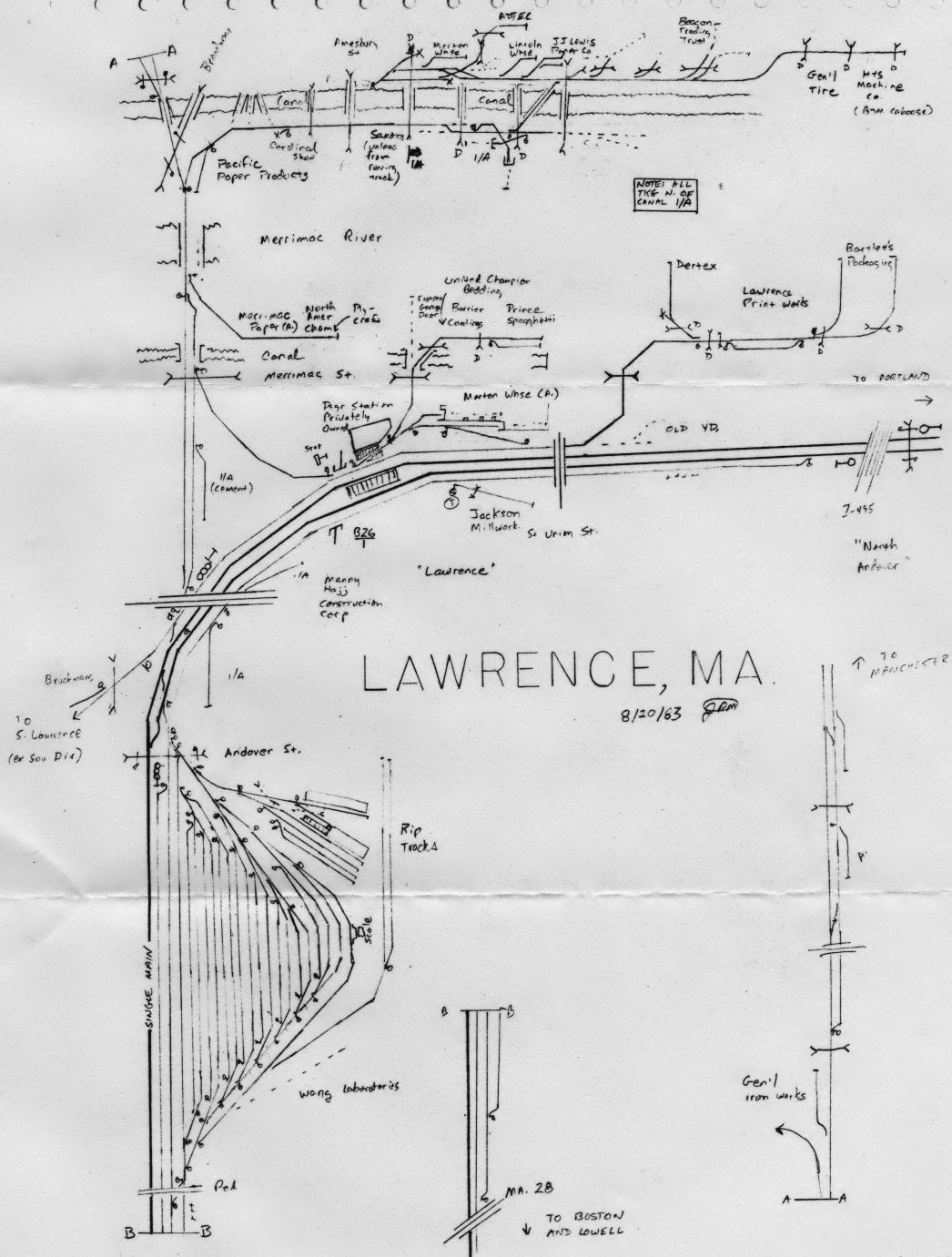
Lawrence: engine terminal (roundhouse extant into 1990s as warehouse) on RH, 2 yard tracks to R of main. Skewed through truss road overbridge, deep rock cut with foot overpass at W. throat of yard - double-ended yard w/freight house (RDC layover point 1965 - 1974) at E end, mill complex along RH edge, busy grade crossing w/tender into mid-1970s at E. throat (Andover St). Lawrence Tower (demolished about 1973) on LH at point where industrial spur (former Southern Div. track from Lowell) converges LH. At tower, double track resumes 1976-2014, long sidings on either side of main began, ran to Shawsheen River bridge at North Andover line. Easterly siding ("Track 17") restored to service 2012. Manchester & Lawrence branch diverges in wye on LH to cross Merrimack River on deck truss, main curves RH sharply (45 MPH). Brick 1930s passenger station on LH (later bakery), with 2 mail/express loading spurs (short steel umbrella sheds demolished 1990s). Long umbrella shed on center platform, access originally via underpass, stair from street remains at W. end. Past old station, industries on either side, new station/garage on LH past Union St. overbridge. Large brick mill complex 1/2 block LH along Merrimack River with various spurs (inactive since 1980s).
No. Andover: Final Shawsheen River bridge (26.92), I-495 overpass (post-1964). Machine Shop branch (former Essex RR, cut back from Danvers in 1930s) diverges RH just W of station, climbs sharply and passes behind station (lawnmower shop, heavily modified) at Sutton St. grade crossing. Main line follows Merrimack River (on LH) closely for 2 mi., speed restricted to 60 MPH, turns inland past large Western Electric plant on RH, climbs to Ward Hill (W of Rt. 125 connector overbridge). Plastic pellets still unloaded at plant on RH in North Andover in 2010.
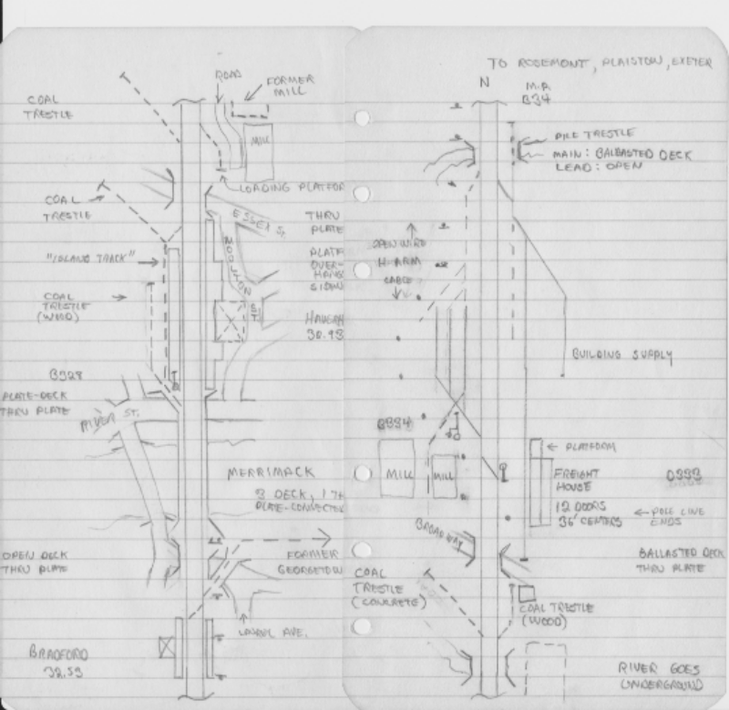
Bradford: Main descends E from Ward Hill on fill, parallels river, small yard, 1956 - 1990 site of corrugated metal freight house and cement terminal on LH (now site of MBTA station and layover yard), Bradford Station on LH (now laundromat), former line to Georgetown diverged RH as main climbs, turns sharply L to cross Merrimack River on steel bridge: track-height stone piers, 3 hanging deck truss spans, 1 through truss span.
Haverhill: Deck and through girder bridge approach W of station. 2-story station at street level on RH in Railroad Sq. demolished about 1960. Platforms elevated, entrance via tunnel and stairs at W end from Washington St. at underpass. W end of slate-roofed wooden platform sheds remained into 1990. New station parking lot on LH of WB platform on site of "island track" and RR-served coal/lumber yard. Line continues elevated to W end of yard (now CP Hall). Five coal trestles along elevated portion between station and freight house. On LH at yard, 8-stall engine house and 60' turntable. Steam engine servicing ended here May 22, 1955. The plans in September 1980 Model Railroader show a coal trestle, not listed in the B&MRRHS reprint 1937 Characteristics Charts . Two tanks, 50,000 and 60,000 gallons are listed; one was wood, 20' dia. beside the roundhouse. The MR yard track plan also has some errors - compare it with the photos. The upgrade to the W indicated on the plan is the approach to the grade separation through the station. The freight house is still extant on RH below main line just E of last road overpass. East of engine house, yard ends at Little River bridge, in undeveloped area.
Plaistow: Large woodworking plant formerly on LH W of NH Rt. 121A grade crossing. End of double track after about 1970. Station on LH (recently renovated) E of crossing.
Newton Jct: Pre-1960, station on RH W of grade crossing, 100 car sidings on either side of double track main E of grade crossing. Merrimack branch (abandoned Feb. 1972, map, history and steam-era photos in Vol. 10 #3/#4 (Spring & Summer 1981) Bulletin) diverged RH in wye E of grade crossing.
Powwow River: Cross lake on fill, flagstop signal mast on RH. Spur (occupied by privately-owned wood former B&M caboose in 1960s) on L, NH 107A overpass to E.
East Kingston: Freight house on L (destroyed 1990s after spur removed), 2 story frame station/residence (extant, maintained as museum) on RH West of NH 107 crossing.
Exeter: Wood and brick mill complexes on both sides circa 1950, some still active rail customers into 1970s. Downeaster station on RH just W of stone B&M station (extant) on RH, overpass, descends to parallel Squamscott River (tidal marshes) on RH.
Newfields: Siding pre-1960, post-war industry, main turns L away from Squamscott River. Post-1970, mid-point of controlled siding ending at Rockingham Jct. to East.
Rockingham Jct.: Manchester - Portsmouth branch crossed on diamond until abandoned Manchester - Rockingham in late 1970s. SE wye tight radius, SW wye broader, included runaround. Station in NW quadrant (extant, recently rebuilt), 100,000 gal. steel water tank (footings extant) E of it on LH, freight house in SE quadrant, served from EB main, destroyed post-2000. End of double track W of wye switches mid 1960s to 1970. Plan of station in September 1957 Model Railroader , HO scale kits of station and freight house offered B.E.S.T.
Newmarket: Lift-up crossing barrier in service at NH 108 grade crossing into 1950s. Station still standing on RH. Long spur from mill buildings by river converges RH E of station.
Durham: Station still standing E of road overpass, in use by Downeaster. Rotating flag stop signal opposite still largely intact in 2012.
Madbury: Large gravel pit active into 1970s on LH
Dover: Dover Arch - 100 foot tunnel through a ridge with a street passing over (end of double track 1957 - 1960s), downgrade into Cocheco River valley, cross on steel deck truss. On E bank, stubs of former Cocheco RR (Portsmouth - Dover - Rochester - Laconia) converge RH and LH, final passenger station (1 story yellow brick, flat roof, built late 1950s) on RH until replaced by new station for Downeaster. Earlier 3 story yellow brick station and division HQ was on RH between grade crossings just E. Photos, track/signal diagram in February 1965 Model Railroader. Photos, discussion of circa-1950 operations in Vol. 22 #3 Bulletin. Through truss over road (begin double track post 1957), yard on both sides. Office, freight house on LH, engine terminal on RH at E end, against embankment for road overpass closed circa 1982, brick roundhouse still extant (85' turntable, wood coal tower, two 50,000 gal. wood tanks).
Rollinsford: After 1960, end of double track from Dover, wye (power switches) to Conway branch on LH, deck truss over Salmon Falls River to E.
So. Berwick: Deck truss over Salmon Falls River. East of town, former Eastern RR roadbed from Kittery parallels B&M 100-400 yards on RH to No. Berwick.
No. Berwick: Eastern RR from Kittery (abandoned 1952) converges RH. 100,000 gal. tank in steam era. Station on RH side still extant. Short CTC siding through town from removal of double track until Downeaster track rebuilding. East of station, Eastern RR to Biddeford (abandoned 1945) continued straight, B&M swings RH towards Wells and coast.
Wells: Current Downeaster station on RH W of I-95 overpass. B&M station at MP 84.85, close to US 1.
Kennebunk: 50,000 gal. tank. Station still extant, W of ME 35. Site of two boxed pony truss road overpasses into the 1990s.
Biddeford: Former Eastern RR converges LH near Alfred Rd. (beginning of double track after 1960s) and ran parallel. 'AR' Tower located at Alfred Road, controlled CTC in the area until the 1970s. Eastern RR stub serving industrial park in Saco diverges LH. 50 ton coal bin, hand shoveled. One-stall enginehouse for the switcher (a GE 44-tonner after WWII) survived into the 1970s.
Saco: Water standpipe, no tank. Present Downeaster station on RH on island between two dams/waterfalls of the Saco River.
Ocean Park: End of double track from AR post 1968.
Old Orchard Beach: Track runs 1 block W of main drag along beach w/many cottages, businesses, amusement park.
Pine Point:
Scarboro Beach:
Portland Terminal Tower 1: End of B&M track at W end of Rigby Yard. Clapboard tower discontinued in 1950s.
The former Newburyport Branch Railway was built from Wakefield Junction on the then B&M through Lynnfield, West Peabody, Danvers, Topsfield, Georgetown, Byfield (Newbury) to Newburyport, to compete with the Eastern RR. Sortly afterward, a line was built from Georgetown to Bradford station in Haverhill, MA. By 1890, it had junctions with the South Reading branch to Peabody in Wakefield, the Salem & Lowell from Peabody at West Peabody, and the Danvers Branch (Essex RR, also from Peabody) at Danvers.
In 1941, the track was abandoned from Topsfield to Newburyport and removed between Georgetown and the paper mill in Haverhill. Passenger service to Topsfield lasted till 1950, when it was cut back to Danvers, then in 1959 to a short turn at Wakefield Center that only lasted a couple more years. The line from Danvers to Topsfield was abandoned about 1970, the remnant of the Salem & Lowell from Peabody to South Middleton several years later. The remaining bits continued to have some local freight traffic into the late 1990s, but are now all being made into a rail trail.
From the mid-1930s to 1957, the segment from Wakefield to West Peabody was used by the High Car Job, which handled cars too big to fit through the Salem Tunnel. It then used the Salem Branch (former Salem & Lowell) to Peabody and the small yard at Northey Point in Salem. A manual interlocking remained in service at the West Peabody diamond into the 1960s (I saw the plant used for an RRE fan trip in 1968, though it had been removed from the Employee's TT by 1966).
The RoW is visible at many places; the segments from Newburyport to Danvers and Haverhill are maintained for vehicle access to power lines. From Danvers to Wakefield is heavily overgrown, though the RoW is quite visible at its bridge over Rt. 114 and the grade crossing with US 1 in Peabody.
Built primarily to serve mills near downtown Merrimack, MA, this branch lost its last customers and was abandoned in Feb. 1972. A map, history and steam-era photos are in the Vol. 10 #3/#4 (Spring & Summer 1981) Bulletins. The MA portion is a rail trail, and several bridge abutments are still extant.
Originally built from Portsmouth to Concord, NH, but purchased by the Concord RR. In order to maintain its Manchester - Concord monopoly, the CRR hoodwinked the State into allowing it to reroute the line to Manchester. It joined the B&M when the CRR was leased.
On-line traffic was mostly local deliveries with a few industries and gravel pits shipping outbound. Two daily round-trips provided passenger service into the 1950s. The mixed that replaced them was discontinued ?1958?. Overhead traffic included tide coal and petroleum from Portsmouth, but never justified rebuilding to main line standards. As ties rotted and on-line industries closed, the Manchester - Rockingham Jct. portion was abandoned and torn up in the 1970s. It is now a rail trail. Rockingham Jct. to Portsmouth still handles several freight moves a week.
Raymond: Raymond, NH depot is preserved, with several pieces of equipment including steel caboose C-32.
Epping: Worcester, Nashua & Portland line crossed west of Calef Rd. (NH Route 125). SE leg of wye left in place after WN&P abandoned to connect remnant line to Fremont, NH.
Rockingham Jct.: Diamond crossing of Western Route, double track till about 1970. Station still stands, diamond and all but the SE wye leg removed. Line remains in service from here to Portsmouth.
Greenland: Station still stands.
This line was originally built as the Portsmouth, Great Falls & Conway primarily for lumber traffic This declined as the old growth was cut, and by WWII vacation passenger traffic and inbound local freight traffic predominated. After WWII the route of the summer-only Mountaineer, a vacation-oriented express from Boston to Fabyans on the Maine Central. Despite impressive timings for RDC trains in the later 1950s, passenger service ended in 1961.
Abandoned from West Ossippee to Intervale in 1973. Rollinsford - West Ossippee sold to gravel pit operator's New Hampshire North Coast RR. Conway Center - Intervale sold to Conway Scenic Railway. Article on modeling the branch in December 1988 Model Railroader, including building the ornate North Conway station (extant). North Conway station has also been offered as an HO scale kit.
Somersworth:
Rochester:
Union: Depot LH just S of highway crossing. Union is a village in the town of Wakefield, NH. The depot houses a museum, with preserved equipment and RR structures on its grounds.
Wakefield:
Sanbornville:
West Ossippee:
Mountainview:
Silver Lake: Preserved depot on RH, has been the starting point of a motor car tourist line.
Center Conway: Preserved depot on RH south of NH 16 grade crossing is south terminus of Conway Scenic Railway 'Valley Trains'.
North Conway: Short, steep grade up from floodplain to station area level with town. Ornate 2-story station RH, small yard, 85' turntable, 4-stall roundhouse, freight house, small yard LH.
Intervale: Maine Central Mountain Division line from Fryeburg, ME converges RH. Two double-ended sidings, small station demolished late 1950s.
The Worcester - Ayer segment was built as the Worcester & Nashua RR, later the Worcester, Nashua & Portland. But its on-line business was much less than the Western Route's, and its grades were substantially worse. Once acquired by the B&M, most traffic was through freight from Worcester to New Hampshire and Maine. After WWI there was one last burst of traffic while Western Route bridges were strengthened, and then through Worcester - Portland freight was diverted via the Stony Brook (Willows - N. Chelmsford) and Lowell (Bleachery - Lowell Jct.) branches. The automatic block signals were removed starting Aug. 1929 and abandonment east of Nashua began in 1932.
Worcester had numerous on-line industries, and was also a major interchange point with the New Haven RR. The New Haven competed for Northern New England traffic primarily via its Maybrook, NY gateway to the Erie, L&HR, L&NE, (and via them the PRR, DL&W, LV, and CNJ/RDG/B&O). Until the Penn Central era, considerable time-sensitive merchandise traffic between New York City, Western Connecticut and Northern New England was routed through Worcester.
In the depths of the Depression in 1931, the B&M and the New Haven made Joint Facilities agreements for Worcester, Springfield, Fitchburg and Lowell. In Worcester, the B&M Garden St. yard and engine terminal were abandoned in favor of the NH's South Worcester facilties. Joint operation extended from Hope Ave. and Millbury on the NH side to Summit and Holden St. on the B&M. Passenger trains always originated or changed RR and crews at Worcester Union Station.
Conventions are Eastward is towards Lowell Jct. (matching the Western Division), Right is toward Boston
Worcester: Connect at elevated Worcester Union Station with New York, New Haven & Hartford and Boston & Albany. Almost all freight, passenger interchange with NH. Many photos in New England 1930s Steam Action: Worcester. More photos, maps, discussion of operations in NHRHTA Shoreliner 40-3 and 40-4.
Exchange St. (0.33) Tracks returned to street level.
Lincoln Sq. (0.76) Grade separation tunnel replaced original alignment 1956.
Garden St. Yard (1.56) Built by the B&M in the '20s to replace smaller facilities closer to downtown, engine terminal had a concrete coaling tower. Out of service by 1933 but remained in place till WWII.
Barber (3.99) Line to Gardner (sold to P&W 1974) diverges left.
Summit (4.61) Burncoat St. Top of grade from Garden St. Heavy freights were often helped to this point by a yard engine.
Oakdale (10.15) Crossing point of Central Mass. line prior to construction of Wachusett Reservoir. Central Mass. line to Rutland and Barre diverged left until abandonment Dec. 1939
Sterling Jct. (11.90) Former Fitchburg & Worcester (later OC, then NH) connected right until abandonment to Pratts Jct. 1937.
Clinton Jct. (14.93)/East Switch (15.82) Central Mass. line connected from right with a wye between construction of the Wachusett Reservoir until abandonment August 1958.
Clinton (16.76) NH Framingham - Fitchburg line passes over on elevated track at shared station. 200 car siding after 2nd track was removed 1961-2.
Clinton Engine House (17.46) Teminal for locomotive-hauled Central Mass. trains till closure when dieselized in 1956.
Lancaster (19.19) Stop for Worcester-Lowell locals through WWII.
Ayer (28.01) 'Hill Yard' (later auto unloading facility) along Worcester Main Line west (compass south) of wye to Fitchburg Division (which see).
Willows Remote interlocking where Fitchburg Div. line to Acton and Boston goes right, Stony Brook Branch to North Chelmsford goes left. When the Stony Brook was single tracked in 1958, a short stretch of double track was left between Willows and Willows East, later North Littleton.
Most Worcester Route freights and passenger trains entered the Stony Brook but a daily freight and until the late 1950s a mail/express train operated to Boston. Fitchburg Div. freights bound for Rigby or the NH Division also used the Stony Brook.
Graniteville West end of middle siding in the double track era.
Westford East end of middle siding in the double track era.
North Chelmsford Stony Brook meets NH Division main line at a wye. See NH Div entry.
Some Worcester Route freights and at times passenger trains turned toward Nashua but most continued through Middlesex to Lowell.
Bleachery 0.89 miles south of Lowell, past Lowell Tower and the wye connecting the New Haven's Framingham - Lowell route, the Lowell Branch diverges left and runs along the north side of Bleachery Yard.
Wamesit East end of double track after about 1970.
Tewksbury Salem & Lowell Branch connected in wye RH, also continued N through underpass just E to terminate at Lawrence Branch (originally Lowell & Lawrence RR).
Lowell Jct. Meet Western Route at a wye. End of double track just west of switch after north wye single tracked until about 1970. See Western Route entry
Conventions are Northwards is towards White River Jct. (timetable direction circa 1958), Right is towards the ocean.
Mystic Junction: Summit of Yard 7 and Yard 8 humps, receiving yard converges LH. 4 tracks under Rt. 28 overpass, into cut.
Somerville Junction: Hill Crossing Freight Cutoff (originally Lexington Branch) diverges LH. Many industries on either side of tracks here to Medford.
Medford Hillside: Not a station in the 1950s, but after the MBTA bought the RoW and equipment, for a number of years some trains stopped at College Ave. Large industries (Stone Container plant and others) on LH approaching Alewife Brook Parkway. Concrete arches over parkway and the Mystic River.
West Medford: Grade crossings for local street, Route 60. Station formerly on LH. Center siding ran from station considerable distance towards Wedgemere.
Winchester (MP 7.82): Tracks elevated circa 1954 through Wedgemere (MP 7.34) past Winchester and some distance towards Woburn and Montvale. Elevated stations, Winchester Tower at ground level on LH. Crossovers where Woburn Loop (stub abandoned 1981) diverged LH. Bi-directional double track from here to Wilmington post-WWII. Small yard for switching industries on LH before Cross St. underpass. Larger yard on LH at Montvale (Stoneham Branch diverges RH).
Wilmington (MP 15.20): Present Mishawum station on LH by Rt. 128 overpass, crosses marshy area with a number of large industries in South Wilmington. Present Anderson station on site of chemical plant. Woburn Loop converges LH at North Woburn Jct. (MP 13.97). Pre-1990, three signalled tracks to Wilmington, station on RH. Rightmost track diverges to Wildcat line to Western Route at Wilmington Jct. Yard, office, site of coach yard and engine house in angle between the lines. Large industry on LH.
North Billerica (MP 21.79): At East Billerica (MP 19.22) lead to Billerica Shops complex diverges LH. With remnant of former Bedford - Billerica line to North Billerica, formed a wye which remained in service into the 1970s. Branch converges LH, ran parallel to main for several hundred yards through station area; Station on LH N of road overpass. Post-WWII industrial park on either side of main here almost to Lowell, but no large customers that I know of.
Lowell (MP 25.55): Yard lead began on RH well S. of I-495 overpass. Bridge over Nashua River is stone arch (possibly Boston & Lowell vintage) for main on LH, pile trestle for yard tracks on RH. Southerly yard mostly disused since 1970s. Bleachery (MP 24.66) yard on LH approaching junction with double-track Stoney Brook Branch from Lowell Jct. Yard office, RIP track and engine service on N. side of Stoney Brook. Long industrial spur into Lowell mill buildings diverges by office. N. of junction, abutment remained from former competing line to Lawrence, with steep curving ramp Left and up from NH Div. main line to access industries. Lowell Tower on LH at wye where New Haven line from Framingham enters. Yard continues on RH under Lowell Connector, tracks used for mainline pickups/setoffs. Lowell station (2 platforms, 4 tracks), late 1950s McGinnis station on RH. Old station located N. of cut where industrial spur to mills downtown diverges RH. Main turns sharply LH towards Middlesex and North Chelmsford.
Middlesex: Engine terminal and coach yard next to Merrimack River on RH of the main line tracks, abandoned at the end of locomotive-hauled passenger service to Lowell. Last steam serviced May 2, 1955, closed 1958, burned 1975. Article with photos, track plan in B&M Bulletin Vol. XXVI #3
North Chelmsford: Stony Brook Branch wye on LH, station was located inside wye. Wood tower on river side downstream, removed when CTC controlled from Lowell Tower installed. North leg was always single track, south leg double until about 1970.
Tyngsboro: Line on west bank of Merrimack River, station LH.
Nashua:
Manchester: 2-part article with photos and 1898, 1963 station plans in B&M Bulletin Vol. XXVII #3, XXVIII #2.
Hooksett:
Bow Jct.: North end of the Suncook Loop, which was retained until the Suncook Valley RR was abandoned in 1952. The bridge piers are still visible on R.
Concord: Large Blue Seal feed mill on L as line runs close to the Merrimack River. Former Concord Shops buildings (closed Summer 1958) on either side of the main, location of engine terminal until end of steam circa 1952. Tower on L at overpass at S. end of freight yard, also on L. Passenger station with arched trainshed was on the L at N end of yard, demolished circa 1960. 1-story flat roofed cinder block station replaced it, remained as bus station through late 1980s. Boston, Concord & Montreal main to Laconia, Plymouth and Woodsville (severed 1954, thenceforward the White Mountain Branch) diverges R. and crosses the Merrimack river on a through truss bridge. Contoocook Branch (later Claremont & Concord RR diverges left as the main to White River Jct. turns left. Ball signal where freight yard entrance track crossed B,C&M track. Many photos in Railroad Cities: Concord, NH.
Penacook:
Boscawen:
Gerrish:
Franklin:
Halcyon: 87 car siding until abandonment.
Andover:
Potter Place:
Gale:
Converse:
Danbury:
Grafton:
Cardigan:
Canann:
Pattee:
Enfield:
Mascoma: 75 car siding until abandonment.
Lebanon:
Westboro: Renamed from West Lebanon 1920s. Beginning of double track to White River Jct. Industries and station RH, engine terminal LH on curve approaching Connecticut River deck truss bridge.
Route from Concord to Woodsville NH and Wells River VT competed with the Northern RR route via White River Jct. until consolidated into the B&M in the late 1800s. The line followed the Merrimack River, then the Winnepesaukee to the lakes, then the Pemigewasset to Plymouth and finally the Baker River to the Connecticut River divide west of Glencliff.
De-emphasized as a freight route after 1930, it was never upgraded for longer trains or 2-8-4, 4-8-2 or P-4 4-6-2 steam power. Block signals were removed between Plymouth, NH and North Haverhill NH in 1933. Plymouth - Haverhill was abandoned in 1954. The rest of the line remains intact, owned by the State of NH, though there's been no freight North of Laconia since the 1970s. A tourist RR operates South from Meredith to Laconia.
Canterbury: 4 car siding.
Tilton: 36 car siding
Winnisquam: 49 car siding
Laconia:
Lakeport:
Weirs Beach: Station on Lake Winnepesaukee waterfront, connection to M.V. Mt. Washington. 14 car siding.
Meredith: Station RH as line turns away from lake, still extant. 46 car siding.
Ashland: Station RH, preserved as museum. 28 car siding. Trailing point spurs on RH drop down steeply to paper mills.
Plymouth: Engine facilities LH, large station on LH still extant, White Mountain Branch diverges RH to through truss over Baker River.
Rumney: 31 car siding.
Wentworth: 20 car siding.
Warren: 23 car siding.
Oliverian: 45 car siding.
Haverhill: 17 car siding.
A tourist RR leases rights on the White Mountain Branch South from North Woodstock. Some trips go as far as Campton.
The Fitchburg RR completed the initial segment to Fitchburg, MA in 1845. The line up the grade through South Ashburnham, Gardner and Athol to Millers' Falls was completed by the Vermont & Massachusetts in 1848 and extended to Greenfield, MA in 1850. The Troy & Greenfield completed its route in 1875 when the Hoosac Tunnel was opened. The Boston, Hoosac Tunnel & Western built parallel to the T&G and then from Johnsonville to Mechanicville and Rotterdam Jct. in 1879. The Fitchburg had acquired quite a few other lines before the B&M leased it in 1900.
Conventions are: West is towards Rotterdam Jct., Right is towards Canada, Diverge is facing point going West.
Union Sq.: Boston & Albany/NYC/PC/CR/CSX Grand Junction Branch crosses on diamonds, receiving tracks for Mystic Jct. hump yard crossed above in multi-track through truss bridge removed circa 2000. Double track main with industrial running tracks on either side from beyond B&A diamonds to West Cambridge.
Cambridge: 2-story station with pedestrian overpass on R demolished circa 1960. Industrial running tracks passed through platform paving.
West Cambridge: Watertown Branch diverges L., Lexington Branch (former through route to Billerica) diverges R. Small freight yard on R (now MBTA maintenance facility), local industries in Fresh Pond area on both sides of tracks.
Hill Crossing: Hill Crossing Freight Cutoff (former Central Mass. RR route from Somerville Jct. on NH Route) converges R. Central Mass. single track parallel on R to Clematis Brook through 1954.
Belmont: Station elevated above street level.
Waverly: Tracks depressed for grade crossing elimination in early 1950s, which also eliminated the separate Central Mass. line.
Clematis Brook: Central Mass. Branch diverges R, interlocking and crossover after grade separation project.
Beaver Brook: After 1958, east end of single track segment to Waltham implemented to provide clearance for TOFC traffic.
Waltham: Watertown Branch (later Bemis Branch after it was severed) converges L. Station on R demolished circa 1960, tower on L remains. Post-1980 station West of grade crossing.
Willows: After 1958, west end of single track segment from South Acton (double track being restored 2012). Stony Brook Branch from North Chelmsford converges RH. Wide RoW on RH was formerly a separate Stony Brook track to Ayer. Facing point 2-track RDC yard located on this roadbed 1960 - 1980s.
Ayer: Tower, former station on RH. Wye to Worcester line on LH, Hill Yard at Worcester end of wye. Branches to Hollis, NH (former Worcester, Nashua & Portland main) and Greenville NH diverged RH W of station. Former WN&P had crossed at a diamond in the middle of the wye. Through WWII Stony Brook Branch paralleled the Fitchburg on the north to Willows.
..... under construction .....
Williamstown, MA:
North Pownal, VT:
The separated main lines between State Line Tower and Johnsonville were originally built by two railroads. The first right of way was opened between North Adams, MA and Troy NY by the Troy & Boston Railroad in 1859. After the Commonwealth of Massachusetts took ownership of the Hoosac Tunnel, the Boston, Hoosac Tunnel & Western built a line from Rotterdam Jct., NY to North Adams. This opened in 1879. In 1887, the Fitchburg RR bought both lines. Track arrangements and the use of left-hand running for favorable grades over the years are explained in detail in B&M Bulletin Vol. XVI #1.
Petersburgh Jct., NY: Until May 1953, diamond crossing of Rutland RR. Corkscrew Division line from Bennington, VT to Chatham, NY. Station in NW corner of diamond.
Hoosick Falls: The Westbound track crossed above the Eastbound at the depot, which was built to serve both levels.
Hoosick Jct.: Bennington Branch from Bennington, VT joins in a wye on the east side of the main lines. Freight and passenger connection to Rutland RR, later Vermont RR at North Bennington, VT.
Eagle Bridge: Delaware & Hudson (Batten Kill RR after 1982) line from Castleton VT and Salem NY convverges from the northeast.
Johnsonville: Troy Branch (original Troy & Boston RR, abandoned 1972) diverges left at JV Tower (construction article in Nov/Dec 1991 Mainline Modeler)
Schagticoke: Middle siding in steam era. Line turns west away from the Hoosick River and continues downgrade. Crossing three different brook drainages, it turns north toward the Hudson River bridge.
Stillwater: East Saratoga Jct. and West Saratoga Jct. were two ends of a yard serving a paper mill.
Mechanicville: Cross the Delaware & Hudson main line toward Albany at XO Tower. B&M yards on south side of joint main lines, D&H on north side.
Crescent: Interlocking in Burnt Hills, NY where D&H main line diverges north. In 1965, the D&H built a new wye connection and moved its route north of Mechanicville to the shared track with the B&M, abandoning the former line to Ballston.
Scotia: Lead into Naval Depot diverges south. two ends of a yard serving a paper mill.
Rotterdam: Several yard tracks parallel to main line used for changing locomotives and swapping blocks. Rotterdam Jct. about a mile west is the westernmost point on the B&M. There it connects to the NYC/PC/Conrail/CSX former West Shore freight route west from Selkirk NY.
By 1900, double track throughout, single tracked and CTC installed by 1950. Passenger service ended 18-Jan-1958. The entire branch was abandoned and torn up in November, 1972.
Valley Falls: Still a passenger stop in the 1950s
Melrose: CTC siding location after single-tracking.
Lansingburgh: Located in North Troy, this station was discontinued as a passenger stop in the 1930s.
Troy: Double track began at a spring switch at Reilly's (about mile B187.8) post-CTC, continued to Union Station. Article with discussion of operations and track diagrams of the station and yard in the Fall 1982 Bulletin. Troy Union Station was built in 1903 and demolished in the winter of 1958-9. The D&H rerouted its connections to the NYC in the 1960s and abandoned its line to Troy. CSX still provides freight service to Troy from Rensselaer along the east shore of the Hudson River.
The Troy Union Railroad owned and controlled operations over track between Hoosick St. (B&M) and Adams St. (NYC), and from the wye to the beginning of the D&H Green Island bridge. The B&M freight yard and freight house were between Hoosick and Middleburgh Streets between the main line and 8th Ave. The passenger yard was opposite along 6th Ave.
Line from Somerville Jct. to Hill Crossing in West Cambridge became the Freight Cutoff about 1927. Crossed Lexington Branch (embargoed Feb. 1981) at Fens Crossing near Alewife Red Line station. Abandoned when the MBTA's Red Line was extended through Davis Sq. in Somerville.
Line from Hill Crossing to Clematis Brook abandoned as part of the 1950s Belmont grade separation.
The original through route was abandoned between the trackage shared with the Worcester - Ayer line in Clinton, MA and Wheelwright MA during the 1930s. Passenger and freight service continued from Clinton, MA (engine terminal) to Boston. Not long after the last steam trip on 4-May-56, passenger service was cut back to Hudson, MA and the line from Marlboro to Clinton Jct. was abandoned.
Passenger service was cut back to South Sudbury, MA in 1965. South Sudbury (diamond crossing of Old Colony Framingham - Lowell line) to Marlboro MA was abandoned in the late 1960s. Passenger service from Clematis Brook through Waltham to South Sudbury ended about 1972. Freight service west of Waltham North ended Aug. 1980. Most rail and bridges remain in place as NIMBYs fight rail-trail proposals.
This line was begun by the Vermont & Massachusetts RR, which built from Fitchburg, MA over the summit at Gardner and down the Miller's River to Millers' Falls, thence up the Connecticut River to Brattleboro, VT. in 1850. Construction by the Connecticut River RR (Springfield - Brattleboro), Vermont Valley (Brattleboro - Bellows Falls) Sullivan County (to Windsor), Vermont Central (to White River) and Connecticut & Passumpsic (past Wells River) eventually completed the line. Conventions are Northwards is towards White River Jct. (timetable direction circa 1958), Right is towards the ocean.
Springfield: B&M ended at Boston & Albany diamonds West of Union Station. Connecting tracks LH into station, Tower roof removed with I-91 construction. B&M used NY,NH&H engine terminal and passenger yard south of the B&A, NH used B&M freight yard after mid-1930s under shared facilities agreement. Article with photos and track plan in B&M Bulletin Vol. XXIX #3. Many photos in Railroad Cities: Springfield, Mass..
Scott Whitney's article on modeling the branch in May, June 1997 Railroad Model Craftsman
Maintained by James B. VanBokkelen .